Early states tended to emerge in places that were actually somewhat marginal for agriculture, quite counterintuitively. (Most recent discussion here.) When combined with the example of China (which is not at all marginal for agriculture), the connecting argument that emerges is that states appear where central coordination of labor is required for agriculture, there is a benefit to population, and a centrally organized society develops. This can occur either because of marginal conditions (e.g. timing the flooding of a river surrounded by a vast desert) or difficult crops that require more central coordination, e.g., rice. Conversely, in places where the land easily produces calories, there is little benefit to central coordination, as dissatisfied "citizens" can easily refuse to cooperate and move away, and not lose any benefit in terms of population growth.
One way to test this would be to look at political stability within an early state - within a single early state - and how stability correlates with agriculture-favoring (or -disfavoring) climate changes. This hypothesis (CLAHSF) would be falsified if improved conditions outside the central areas of a state improved state stability, and if worsened conditions outside the central area de-stabilized the state. Ola Olsson from the University of Gothenburg shows that in fact, when the ancient Egyptian "hinterlands" received better rainfall (which improved agriculture in a desert climate), there was a delayed de-stabilizing effect on the Egyptian state, "since the decline in effective circumscription provides the farming population with an outside option in the hinterland."
Ola Olsson (University of Gothenburg), "Pharaoh's Cage: Environmental Circumscription and Appropriability in Early State Development", IAST General Seminar, Toulouse: IAST, March 29, 2019, 11:30–12:30, room MF323.
Showing posts with label agriculture. Show all posts
Showing posts with label agriculture. Show all posts
Thursday, March 28, 2019
Sunday, April 29, 2018
States Emerged In Places With Marginal Agriculture Potential That Benefited From Central Control
I. More Evidence for the Argument That States Emerge When Food Production Benefits from Central Control
If you looked at climate and climate alone, Egypt, the Fertile Crescent, the Andes and the Mexican Plateau would not seem like optimal cradles of civilization. And yet, it's exactly these kinds of marginal places where states first emerged. Yes, those places are hotter and drier than they were during the neolithic, but they still weren't better suited for cultivation than other places with more arable land. They're dry, they rely on rivers, and in some cases there's considerable altitude. So why there?[1] Why did we not first have large states in the Pacific Northwest of North America, or the southern (wetter) African Sahel, or the (early, but not first) wet parts of the Mediterranean? No, it had to be at the edge of the Sahara, or in the highest mountains outside Asia.
The immediate counterargument to such a theory is one word: China. Any theory of early state emergence that does not include China is not much of a theory of early state emergence. And if we're assuming that the cause is marginal conditions for agriculture, we definitely can't explain China, since the Chinese coastal plain is ideal for agriculture and for transporting agricultural goods. Is there still a commonality? One argument is that anywhere conditions are such that farming only works with central coordination of labor - but with such coordination, it really works - you have the conditions for a state. Planning your crops in a harsh environment and relying on the flooding of a river, as in Egypt would be one such setting. Another would be an otherwise fertile environment but where the grain of choice was hard to harvest alone, but paid off handsomely when harvested with central coordination.
In a review of Fernand Braudel's Civilization and Capitalism, Reddit user lunaranus quotes Braudel and then expands on him:
II. A Side Observation About Genetic/Cultural Quality vs. Climate as an Influence on Propensity for Regional Dominance, Toward a Macro-Theory of History
There's also the argument - though this makes some people uncomfortable[2] - that people from climates with wider annual temperature extremes are more behaviorally adaptable, and therefore when they encounter people from less extreme climates, they "win". To the surprise of many, the closer to the poles you are, the more extreme the annual temperature difference (the temperate regions are NOT the most extreme.) That is to say, during the summer Arctic regions are at or close to room temperature but can get to -50 C or worse in the winter. (Is -50 C really that different from - 30 C to humans, livestock and agriculture? Maybe this could be adjusted by "meaningful" temperature variation, but I digress.) Sure enough, the history of China is a history of more northerly groups (including, in two cases, non-Han steppe people) taking over territory to the south. The history of India is a history of Indic speakers coming from the north-northwest and displacing Dravidians. In North America, Na-Dene speakers migrated from the northerly Alaska/Yukon region, displacing people throughout Western North America, just in the last millennium. And of course in 2018 it's Germany, not Rome, that has most influence over the continent. Of note: I recently visited the site of Carnuntum, a Roman garrison town frequently visited by Marcus Aurelius, who was trying to keep the Germanic tribes out of the Empire. At the time he celebrated some successes, commemorated with carvings on cliff faces occasionally like the one in Trencin, Slovakia. But Since Carnuntum is now in Austria we can see how successful he ultimately was.
Of course that begs the question of why we haven't all been conquered by the Inuit already. The pattern of the Germanic takeover of northern Europe gives us a clue. The first Germanic-speakers appeared in non-Scandinavian Europe around 120 BC, migrating from (guess what) farther north in Scandinavia. Even in Julius Caesar's time seventy years later, the Celts were still his main concern. It wasn't until the mid-second century that the Germans were a major concern for the empire, with their numbers now growing after settling in the lands north of the Danube. The idea is this: Scandinavia has more extreme temperature and bred more adaptable people, but it's just too cold to grow enough food for the population to expand (the region still only has 26 million today, fewer than California.) After three centuries of farming in the much-more hospitable northern "mainland" Europe, their numbers had grown, and now they were ready to take on the Roman Empire, which lasted only three more centuries after that. So we have our time scale: six centuries from crossing the Baltic to destroying the Western Roman Empire. (You could even make the argument that Braudel's southern Chinese expansion was actually northern Chinese - Han - who had settled in what was previously tribal areas, done under the more stable-appearing timeline of centralized governments.)
And there we have the outline of a macrohistorical and demographic theory: states began in areas where food production was difficult, either because of local conditions or choice of food source, but where food production benefited greatly from centralized control. The old centers of civilization give way to waves of people coming from areas of more extreme climate, usually from the north. One prediction that follows from this theory is that the Inuit and related people, given time in warmer more fertile land, will start farming and demographically expanding, moving further south and indeed controlling Siberia and Canada, but this might be simplistic. It's not the mere fact of living where there are temperature extremes, it's that you have to adjust your behavior to seasons. The Inuit did outlast the Norse in Greenland but it wasn't because they were better farmers. Even though the Inuit might have to move to follow fish and game, they're still hunter-gatherers. My expectation is that it's seasonal agriculture which is the key factor to producing more adaptable behavior (read: more effective ability to control behavior to plan for the future.) So that being the case, in the year 3000 look for states in Eurasia dominated by people who are Siberian agriculturalists today. (Seem silly? If you had told Julius Caesar that western Europe would be dominated by German-speakers within five centuries, including former Roman territory, he would have fallen down laughing.)
Things that may have checked this trend in some cases in the past, and could stop it in the future:
The Old Word interrupting this process in the New World. (Obviously.) If there are two continent systems and one of them has both better diffusion of inventions and more territory, chances are that one will be "ahead" in terms of cultural evolution (the Guns, Germs and Steel argument) and it won't be because of more adaptable northerners, but the other continent finally crossing the ocean that your state-originating-center will be overwhelmed (i.e. the Columbian exchange.) Without that you might orthodict (rather than pre- or retrodict, that is, predicting alternative histories, granted untestable) that the Mapuche would have been the Germans to the Incas' Romans, and likewise the Comanche or Lakota to the Aztecs; maybe the Maori to indigenous Australians.
Centers of civilization getting too far ahead of the northerners. Also, there may be a point where the sheer population numbers of the old centers of civilization are so far ahead of the northerners that they can't be overwhelmed. Had the Germans arrived a few centuries later at the edge of an even more-developed Roman Empire, they may not have had the same effect. The communication and transportation capabilities of modern states may exaggerate this effect, so that the Inuit don't have the same opportunity. There is a major asymmetry in modern technology in terms of the capital and manpower it requires. The Germanic tribes and Mongols had technology that was not substantially inferior to the people they were inundating (in some cases, actually superior.) And colonials in Pennsylvania could re-invent medieval metal-working techniques which turned out to be good enough to run off the British, whose weapons were better but not that much better. But it's harder to imagine that a nascent state in the boreal forests distant from Moscow, no matter how adaptable its people, could really produce their own technology to resist the drones and agriculture-attacking Stuxnet malware of even a decadent future Russia.
Technology obviating the need to plan and adjust behavior seasonally. This is the most speculative. Living in a northern OECD country today, do you really have to plan that much for the seasons now? Yes, you reserve your beach house in the summer and get your coats out during the winter, but your life is not directly dependent on your ability to plant and harvest and store and ration food as it would have been until just a few centuries ago. The reign of the northerners may then be over. Of course, just living in such a technologically advanced society requires cognitive discipline and planning, but does that often result in poor reproductive success? Sure enough, in Iceland in the last century, genes associated with educational achievement have become less common. Also curious: there is a known bump in births in September, but I don't know if this extends outside the U.S. Is this just because in January people don't have anything better to do? Or an adaptation so more babies are born during the harvest when there are calories available? (Easy to check: does it persist in US states or other countries with low seasonal variation? Does it differ between ethnicities (forbidden question!) whose ancestors are from different latitudes, living together in a high-variation climate?)
[1] Inferring too much from population patterns in terms of climate and impact on agriculture and the local economy is always a precarious road to go down, especially in parts of the New World that have seen most of their development in the industrial age. For example - population density in the United States drops off west of the 100 W meridian. This is commonly assumed to be due to decreasing rainfall and therefore poorer agricultural productivity, but this is not the case - it's most likely a historical artifact, since aside from a few wagon trains willing to risk the long ride all the way to the coast, until the trains went all the way through and were cheap and reliable enough, people generally just moved a few miles west to start a new homestead. Around 1880 trains had become accessible for most relocating families, and by 1880 that slowly moving population front had made it to about 100 W. Here's the data. What's more, to this day, poorer countries have lower agriculture productivity even with the same or better innate agricultural endowments in terms of soil and climate - see Adomopolous and Restuccia, 2018.
[2] This makes no argument as to whether and what combination of genes and culture mediate this effect - but to drive the point home, either genes affect bodies, or they do not. If we accept that they do affect bodies, it's a very tortured argument to say that for some reason genes cannot affect behavior, since that's saying genes can affect other organs but not the brain. There's a similar gyration you can observe when someone wants to say that culture matters (fair enough) but can't effect outcomes in the aggregate (that is to say, culture doesn't affect happiness or survival.) Either culture matters to outcomes, or it's meaningless static.
If you looked at climate and climate alone, Egypt, the Fertile Crescent, the Andes and the Mexican Plateau would not seem like optimal cradles of civilization. And yet, it's exactly these kinds of marginal places where states first emerged. Yes, those places are hotter and drier than they were during the neolithic, but they still weren't better suited for cultivation than other places with more arable land. They're dry, they rely on rivers, and in some cases there's considerable altitude. So why there?[1] Why did we not first have large states in the Pacific Northwest of North America, or the southern (wetter) African Sahel, or the (early, but not first) wet parts of the Mediterranean? No, it had to be at the edge of the Sahara, or in the highest mountains outside Asia.
The immediate counterargument to such a theory is one word: China. Any theory of early state emergence that does not include China is not much of a theory of early state emergence. And if we're assuming that the cause is marginal conditions for agriculture, we definitely can't explain China, since the Chinese coastal plain is ideal for agriculture and for transporting agricultural goods. Is there still a commonality? One argument is that anywhere conditions are such that farming only works with central coordination of labor - but with such coordination, it really works - you have the conditions for a state. Planning your crops in a harsh environment and relying on the flooding of a river, as in Egypt would be one such setting. Another would be an otherwise fertile environment but where the grain of choice was hard to harvest alone, but paid off handsomely when harvested with central coordination.
In a review of Fernand Braudel's Civilization and Capitalism, Reddit user lunaranus quotes Braudel and then expands on him:
My argument is that this principle applies to the more marginal areas, but the necessity for labor coordination, including irrigation, is really what was important. Any place that could get 1) a big bump in food production from central coordination, and 2) which you couldn't defect from and survive, would favor state formation.Rice is an even more tyrannical and enslaving crop than wheat.The key difference between rice and wheat is that the former can produce ~7.3 million kcals per hectare, whereas wheat can only reach 1.5 million. Unlike wheat, there was no need for fallow land, and bythe 13thC in China a system of double (or sometiems triple) crop was established. "And thus the great demographic expansion of southern China began."
The high population density created by rice, combined with the necessity for elaborate top-down irritation systems, resulted in strong state authority that constantly pursued large-scale works.
II. A Side Observation About Genetic/Cultural Quality vs. Climate as an Influence on Propensity for Regional Dominance, Toward a Macro-Theory of History
There's also the argument - though this makes some people uncomfortable[2] - that people from climates with wider annual temperature extremes are more behaviorally adaptable, and therefore when they encounter people from less extreme climates, they "win". To the surprise of many, the closer to the poles you are, the more extreme the annual temperature difference (the temperate regions are NOT the most extreme.) That is to say, during the summer Arctic regions are at or close to room temperature but can get to -50 C or worse in the winter. (Is -50 C really that different from - 30 C to humans, livestock and agriculture? Maybe this could be adjusted by "meaningful" temperature variation, but I digress.) Sure enough, the history of China is a history of more northerly groups (including, in two cases, non-Han steppe people) taking over territory to the south. The history of India is a history of Indic speakers coming from the north-northwest and displacing Dravidians. In North America, Na-Dene speakers migrated from the northerly Alaska/Yukon region, displacing people throughout Western North America, just in the last millennium. And of course in 2018 it's Germany, not Rome, that has most influence over the continent. Of note: I recently visited the site of Carnuntum, a Roman garrison town frequently visited by Marcus Aurelius, who was trying to keep the Germanic tribes out of the Empire. At the time he celebrated some successes, commemorated with carvings on cliff faces occasionally like the one in Trencin, Slovakia. But Since Carnuntum is now in Austria we can see how successful he ultimately was.
Of course that begs the question of why we haven't all been conquered by the Inuit already. The pattern of the Germanic takeover of northern Europe gives us a clue. The first Germanic-speakers appeared in non-Scandinavian Europe around 120 BC, migrating from (guess what) farther north in Scandinavia. Even in Julius Caesar's time seventy years later, the Celts were still his main concern. It wasn't until the mid-second century that the Germans were a major concern for the empire, with their numbers now growing after settling in the lands north of the Danube. The idea is this: Scandinavia has more extreme temperature and bred more adaptable people, but it's just too cold to grow enough food for the population to expand (the region still only has 26 million today, fewer than California.) After three centuries of farming in the much-more hospitable northern "mainland" Europe, their numbers had grown, and now they were ready to take on the Roman Empire, which lasted only three more centuries after that. So we have our time scale: six centuries from crossing the Baltic to destroying the Western Roman Empire. (You could even make the argument that Braudel's southern Chinese expansion was actually northern Chinese - Han - who had settled in what was previously tribal areas, done under the more stable-appearing timeline of centralized governments.)
And there we have the outline of a macrohistorical and demographic theory: states began in areas where food production was difficult, either because of local conditions or choice of food source, but where food production benefited greatly from centralized control. The old centers of civilization give way to waves of people coming from areas of more extreme climate, usually from the north. One prediction that follows from this theory is that the Inuit and related people, given time in warmer more fertile land, will start farming and demographically expanding, moving further south and indeed controlling Siberia and Canada, but this might be simplistic. It's not the mere fact of living where there are temperature extremes, it's that you have to adjust your behavior to seasons. The Inuit did outlast the Norse in Greenland but it wasn't because they were better farmers. Even though the Inuit might have to move to follow fish and game, they're still hunter-gatherers. My expectation is that it's seasonal agriculture which is the key factor to producing more adaptable behavior (read: more effective ability to control behavior to plan for the future.) So that being the case, in the year 3000 look for states in Eurasia dominated by people who are Siberian agriculturalists today. (Seem silly? If you had told Julius Caesar that western Europe would be dominated by German-speakers within five centuries, including former Roman territory, he would have fallen down laughing.)
Things that may have checked this trend in some cases in the past, and could stop it in the future:
The Old Word interrupting this process in the New World. (Obviously.) If there are two continent systems and one of them has both better diffusion of inventions and more territory, chances are that one will be "ahead" in terms of cultural evolution (the Guns, Germs and Steel argument) and it won't be because of more adaptable northerners, but the other continent finally crossing the ocean that your state-originating-center will be overwhelmed (i.e. the Columbian exchange.) Without that you might orthodict (rather than pre- or retrodict, that is, predicting alternative histories, granted untestable) that the Mapuche would have been the Germans to the Incas' Romans, and likewise the Comanche or Lakota to the Aztecs; maybe the Maori to indigenous Australians.
Centers of civilization getting too far ahead of the northerners. Also, there may be a point where the sheer population numbers of the old centers of civilization are so far ahead of the northerners that they can't be overwhelmed. Had the Germans arrived a few centuries later at the edge of an even more-developed Roman Empire, they may not have had the same effect. The communication and transportation capabilities of modern states may exaggerate this effect, so that the Inuit don't have the same opportunity. There is a major asymmetry in modern technology in terms of the capital and manpower it requires. The Germanic tribes and Mongols had technology that was not substantially inferior to the people they were inundating (in some cases, actually superior.) And colonials in Pennsylvania could re-invent medieval metal-working techniques which turned out to be good enough to run off the British, whose weapons were better but not that much better. But it's harder to imagine that a nascent state in the boreal forests distant from Moscow, no matter how adaptable its people, could really produce their own technology to resist the drones and agriculture-attacking Stuxnet malware of even a decadent future Russia.
Technology obviating the need to plan and adjust behavior seasonally. This is the most speculative. Living in a northern OECD country today, do you really have to plan that much for the seasons now? Yes, you reserve your beach house in the summer and get your coats out during the winter, but your life is not directly dependent on your ability to plant and harvest and store and ration food as it would have been until just a few centuries ago. The reign of the northerners may then be over. Of course, just living in such a technologically advanced society requires cognitive discipline and planning, but does that often result in poor reproductive success? Sure enough, in Iceland in the last century, genes associated with educational achievement have become less common. Also curious: there is a known bump in births in September, but I don't know if this extends outside the U.S. Is this just because in January people don't have anything better to do? Or an adaptation so more babies are born during the harvest when there are calories available? (Easy to check: does it persist in US states or other countries with low seasonal variation? Does it differ between ethnicities (forbidden question!) whose ancestors are from different latitudes, living together in a high-variation climate?)
[1] Inferring too much from population patterns in terms of climate and impact on agriculture and the local economy is always a precarious road to go down, especially in parts of the New World that have seen most of their development in the industrial age. For example - population density in the United States drops off west of the 100 W meridian. This is commonly assumed to be due to decreasing rainfall and therefore poorer agricultural productivity, but this is not the case - it's most likely a historical artifact, since aside from a few wagon trains willing to risk the long ride all the way to the coast, until the trains went all the way through and were cheap and reliable enough, people generally just moved a few miles west to start a new homestead. Around 1880 trains had become accessible for most relocating families, and by 1880 that slowly moving population front had made it to about 100 W. Here's the data. What's more, to this day, poorer countries have lower agriculture productivity even with the same or better innate agricultural endowments in terms of soil and climate - see Adomopolous and Restuccia, 2018.
[2] This makes no argument as to whether and what combination of genes and culture mediate this effect - but to drive the point home, either genes affect bodies, or they do not. If we accept that they do affect bodies, it's a very tortured argument to say that for some reason genes cannot affect behavior, since that's saying genes can affect other organs but not the brain. There's a similar gyration you can observe when someone wants to say that culture matters (fair enough) but can't effect outcomes in the aggregate (that is to say, culture doesn't affect happiness or survival.) Either culture matters to outcomes, or it's meaningless static.
Saturday, June 27, 2015
New World, Non-Malthusian Population More Determined by Historical Accident Than Climate
Above: the Frontier Strip - the westernmost U.S. states before the Rockies - contain the 100th meridian (bold vertical line in maps) which is often used a marker of low precipitation and therefore low agricultural productivity. The argument has been that the population therefore drops off to the west of this; but if that's the case, then why does Canada not follow the same pattern?
It is commonly believed that the population drop-off seen in the United States at the 100th parallel has to do with changes in rainfall and agricultural productivity as one moves west in North America. This article shows that this is probably not the case. It more likely has to do with historical accident - about the time Americans had expanded west to the 100th meridian, we started building trains, and people could move to the more pleasant climates of the West Coast. Note that the "population distribution is by historical accident" theory applies more to the New World than the Old, because of the introduction of intensive agriculture and lack of a Malthusian limit. Maybe over time, there will be a smoother population gradient - it would be easier to argue that with thousands of years of agriculture, longer-term Malthusian limited populations in Asia and Africa populations do reflect agricultural productivity, and therefore also rainfall and longitude-degrees from ocean.
Presumably the same applies to latitude, although for different reasons. Very high latitudes are not great places to grow food. Latitude is still going to be affected by geography (if you're near coastline at 25 degrees latitude, life is much more pleasant than if you're inland) - but the solar radiation remains constant so the effect of latitude is a little less subject to being obscured by the details of geography than longitude would be. (Note that there may be constraints on population growth other than calories that I'm completely neglecting; e.g., maybe agriculture at the equator is better than 30 degrees, but disease slows population growth once you drop below the 30s.)
Geography junkies have likely already seen maps like the one above showing population by latitude, and the assumption is that agriculture just produces more calories at certain latitudes (similar to the provincial precipitation distribution that obtains in North America and which was assumed to influence our own population distribution). But if we're trying to pull out first principles, absolute population doesn't help much - what if there's just a lot of land at certain latitudes? That doesn't tell us whether that latitude is good for agriculture and therefore modern humans, it tells us where the land is on Earth's surface. If your denominator for population density includes ocean, then it doesn't really tell us anything about the carrying capacity of land at that latitude. So population alone won't work - it needs to be population density.
And even just population density per latitude won't work - it has to be population density per actual land area found at that latitude. I couldn't find population density per land area data. Fortunately this Brookings Institute Paper quotes World Bank 1997 figures for land area and population in bands of 10 degrees latitude (see pp 49-51), and I back-calculated population density per actual land area at this level of granularity.

Thinking it might be interesting to see how things stack up when the northern and southern latitude bands are combined, I did so:

(There wasn't full data below 40s south or above 50s north, which means we can't even do 50s when we combine them, which non-ideally eliminates most of Europe.) The question that emerges is, what's wrong with you people in the 30s and 40s south? Up here on the correct side of the world we certainly seem to be able to get along alright in those latitudes. The lion's share of the land in the 30s and 40s south is to be found in the southern half of Australia, most of Argentina and Chile, and South Africa. These aren't bad places to live - note that this contains 3 of the world's 5 Mediterranean climate zones! Again, even trying to smooth things out, historical details matter. These are places where intensive agriculture was only introduced in the last few centuries by Europeans. And geographical details matter, even after using population density instead of population - Australia is an ancient craton with terrible soil, and Argentina is drier than it might otherwise be due to the rainshadow of the Andes. That said, in the Malthusian future, we should expect to see the Pampas filling up much like another Mediterranean climate zone (California) is filling up as we speak.
Finally, it's worth glancing at Malthusian long-term intensive agriculture countries, to see whether this holds up. I've put population density, precipitation and elevation next to each other. China's marked parallels are 40-30-20. India's are just 30-20. (10 crosses near the southern tip of the subcontinent.)
 |  |  |
 |  |  |
The precipitation relationship holds up better for India than for China, but both of them follow elevation. This may be more true in rice-farming areas than other grains. The relationship of population to elevation has been profitably studied elsewhere; there's a notable outgroup in the central Mexican plateau, where grains that enjoy dry conditions are grown and near to where agriculture began in North America.
Fully stated then, the theory can then be summarized as "Population distribution is strongly influenced by agriculture which in turn is determined by climate and therefore latitude, but a) until Malthusian limits are reached millennia after the introduction of intensive agriculture, distribution will be mostly by historical accident as in the New World and b) precipitation and especially elevation dramatically affect the distribution as well."
Wednesday, January 22, 2014
Altitude and Population Density
Cross-posted to my outdoors blog, MDK10Outside.blogspot.com.
We typically go to mountains to get away from it all, especially other humans. I'd always wanted to investigate the relationship between population density and elevation. Surprise! Such a relationship exists. The higher you go, the lower the density; in fact the relationship is even stronger than exponential. Even more interesting than that is understanding why. But first: figure below is from Cohen and Small 1998:

Note the bump at 2,300 m and again at 4,000+. 2,300 is mostly people on the Mexican Plateau, and 4,000 is Tibet + the Andes.
I plugged in data just for ~250 cities in the state of Utah, and got a worse R^2 than I saw for Cohen and Small's data (0.25 vs >0.9 for theirs), but this isnt' that granular; when I tried to do the same thing using mean elevations and population densities for the 50 states it was a mess. I think it would work a lot better at the county level.

So why is this? You might be tempted to speculate that it has to do with the limits of human physiology. That is to say, the higher you go, the more uncomfortable people are (thin air, cold) and the less adaptable, right? It's hard to imagine (for example) that Las Vegas at 665 meters would be a more comfortable place at a lower elevation. And physiologically, as it turns out, in the second half of the twentieth century medical anthropologists studied people in Tibet and the Andes extensively for their physiological adaptations to altitude - the underlying mutations for which have now been characterized (and in the Tibetan case have all occurred in the last 3,000 years!). But the idea that a few hundred meters of elevation will start impacting physiology and population growth falls apart both in terms of common sense and as a direct implication of other work. Any decrease in fertility caused by altitude would cut right at population growth - but this turns out not to be a big concern even for Himalayans living much higher.
You could also argue that the world's large cities tend to be seaports, which are at low elevation, so it's ease of transportation that gives us this bias toward lower elevations; but this is more true for New World that got settled by the sea than the Old World that got settled by land, and people must be pretty lazy if what's keeping them at sea level is their ancestors having gotten off a boat there a few centuries ago.

Terrace farming in the Himalayas.
I bet they would rather just have flat fields.
Beyond some historical accidents, the answer is likely to be mostly "agriculture". The overall population distribution we see in the world today basically reflects how early people in a certain part of the world adopted agriculture and how effective it was, given the crop and the climate, and escaped the Malthusian cycle; hence the highest densities being in a band running from east, southeast, and south Asia. The Middle East started early and although the marginal environment was also a driver for state formation, it was still marginal, and the Fertile Crescent just can't compete with the Ganges or the Pearl River. (So it can be accurately said that on average, humans are Asian; hence this map). So the relationship between elevation and population is really about where agriculture is better, and it's better at lower elevations for many reasons. Otherwise it's hard to understand the Mexican bump at 2300 meters, where (guess what) agriculture was first invented in the New World.
So, if someone ever thinks of a way to do agriculture as easily in the mountains as on flat lands, the days of undeveloped remote mountains are over.
REFERENCES
Cohen JE and Small C. Hypsographic demography: The distribution of human population by altitude. Proc. Natl. Acad. Sci. USA, Vol. 95, pp. 14009–14014, November 1998.
Goldstein MC, Tsarong P, Beall CM. High Altitude Hypoxia, Culture, and Human Fecundity/Fertility: A Comparative Study. American Anthropologist 85(1), March 1983.
We typically go to mountains to get away from it all, especially other humans. I'd always wanted to investigate the relationship between population density and elevation. Surprise! Such a relationship exists. The higher you go, the lower the density; in fact the relationship is even stronger than exponential. Even more interesting than that is understanding why. But first: figure below is from Cohen and Small 1998:
Note the bump at 2,300 m and again at 4,000+. 2,300 is mostly people on the Mexican Plateau, and 4,000 is Tibet + the Andes.
I plugged in data just for ~250 cities in the state of Utah, and got a worse R^2 than I saw for Cohen and Small's data (0.25 vs >0.9 for theirs), but this isnt' that granular; when I tried to do the same thing using mean elevations and population densities for the 50 states it was a mess. I think it would work a lot better at the county level.
So why is this? You might be tempted to speculate that it has to do with the limits of human physiology. That is to say, the higher you go, the more uncomfortable people are (thin air, cold) and the less adaptable, right? It's hard to imagine (for example) that Las Vegas at 665 meters would be a more comfortable place at a lower elevation. And physiologically, as it turns out, in the second half of the twentieth century medical anthropologists studied people in Tibet and the Andes extensively for their physiological adaptations to altitude - the underlying mutations for which have now been characterized (and in the Tibetan case have all occurred in the last 3,000 years!). But the idea that a few hundred meters of elevation will start impacting physiology and population growth falls apart both in terms of common sense and as a direct implication of other work. Any decrease in fertility caused by altitude would cut right at population growth - but this turns out not to be a big concern even for Himalayans living much higher.
You could also argue that the world's large cities tend to be seaports, which are at low elevation, so it's ease of transportation that gives us this bias toward lower elevations; but this is more true for New World that got settled by the sea than the Old World that got settled by land, and people must be pretty lazy if what's keeping them at sea level is their ancestors having gotten off a boat there a few centuries ago.
Terrace farming in the Himalayas.
I bet they would rather just have flat fields.
Beyond some historical accidents, the answer is likely to be mostly "agriculture". The overall population distribution we see in the world today basically reflects how early people in a certain part of the world adopted agriculture and how effective it was, given the crop and the climate, and escaped the Malthusian cycle; hence the highest densities being in a band running from east, southeast, and south Asia. The Middle East started early and although the marginal environment was also a driver for state formation, it was still marginal, and the Fertile Crescent just can't compete with the Ganges or the Pearl River. (So it can be accurately said that on average, humans are Asian; hence this map). So the relationship between elevation and population is really about where agriculture is better, and it's better at lower elevations for many reasons. Otherwise it's hard to understand the Mexican bump at 2300 meters, where (guess what) agriculture was first invented in the New World.
So, if someone ever thinks of a way to do agriculture as easily in the mountains as on flat lands, the days of undeveloped remote mountains are over.
REFERENCES
Cohen JE and Small C. Hypsographic demography: The distribution of human population by altitude. Proc. Natl. Acad. Sci. USA, Vol. 95, pp. 14009–14014, November 1998.
Goldstein MC, Tsarong P, Beall CM. High Altitude Hypoxia, Culture, and Human Fecundity/Fertility: A Comparative Study. American Anthropologist 85(1), March 1983.
Monday, April 22, 2013
Urbanization in the U.S. and Canada
Australia is often used by demographers as an example of a highly urbanized country, but the contrast between Canada and the U.S. is perhaps more interesting, because we're on the same continent. And indeed, looking at a biggest cities comparison list of both countries, it's striking: of the 3 biggest cities in North America, 2 are in Canada. But as you include more cities of decreasing size, the % of Canadian cities in the rank list converges toward 0.1. (Y axis is cumulative % of Canadian cities in the list of biggest cities in North America, of cities with at least 100,000 inhabitants.) Canada's smaller population is enriched for bigger cities.

Even better than the rank list is the difference in urbanization, i.e. the percent population in cities by size. And there it's even more striking: Canada's biggest city alone contains 16.2% of the country's population. To get to that level of % urbanized population in the U.S. you have to add up the first 60 cities.Y axis is % of population in cities, counting cities of decreasing size up to that point (again, as far down as cities of population 100,000).

Climate? Less of a homesteading policy in Canadian history? Less aggressive property purchase incentives in the automobile era? Or Canadian agriculture taking off only post-mechanization (and hence never requiring settlement by large numbers of people in the first place) since the climate is harsher? The thing to do to start distinguishing between these alternatives would be to generate a 3D surface of this last plot with historical data to see if there are any obvious inflection points. And with the last possibility, the question is whether the prairie provinces have areas losing population in the same way that the post-mechanization Midwest has in the U.S. (More on agriculture and settlement of central North America here.)
Even better than the rank list is the difference in urbanization, i.e. the percent population in cities by size. And there it's even more striking: Canada's biggest city alone contains 16.2% of the country's population. To get to that level of % urbanized population in the U.S. you have to add up the first 60 cities.Y axis is % of population in cities, counting cities of decreasing size up to that point (again, as far down as cities of population 100,000).
Climate? Less of a homesteading policy in Canadian history? Less aggressive property purchase incentives in the automobile era? Or Canadian agriculture taking off only post-mechanization (and hence never requiring settlement by large numbers of people in the first place) since the climate is harsher? The thing to do to start distinguishing between these alternatives would be to generate a 3D surface of this last plot with historical data to see if there are any obvious inflection points. And with the last possibility, the question is whether the prairie provinces have areas losing population in the same way that the post-mechanization Midwest has in the U.S. (More on agriculture and settlement of central North America here.)
Sunday, December 26, 2010
Why Is the Frontier Strip Where It Is
Summary: Climate continues to have a profound impact on the distribution and economic activities of humans. There is a rapid population density decrease in the Frontier Strip states. Moving westward, there is a sharp increase in population when the Pacific coast is reached. This is usually attributed to difficulty of farming in the country's interior as the 100 W meridian is approached. I show here that this is not consistent with current agricultural productiveness of Frontier Strip and Pacific states on a per person or per area basis. I also show that in the Frontier Strip, temperature, precipitation and latitude are poor predictors of agricultural output but strong predictors of population density. Population density and agricultural output do not predict each other.
Since the 100 W theory of population density drop-off appears falsified, other explanations must be sought. The appearance of easier transportation during the settlement of the Frontier Strip, as well as the depression are explored and discarded. Further research with better agricultural output data and higher resolution climate data may support the hypothesis that investments in agricultural capital came too early in the Frontier Strip to benefit from irrigation technology, and that modern transportation and U.S. population preferences of climate as well as the coastal location of large population centers with service economies combine to keep the Frontier Strip the low-population boundary of the U.S. interior.
PART 1. I've written enough about the Bad Stripe recently so I thought I'd move to another grouping of U.S. states: the Frontier Strip. The Frontier Strip is the north-south line of states including the Dakotas, Nebraska, Kansas, Oklahoma and Texas, identified retrospectively in the 1890 census as having been the frontier in 1880. I've been interested in the idea ever since I visited Scottsbluff, Nebraska on a road trip two years ago. Like many places in the High Plains, Scottsbluff is proud of its pioneer heritage, although you have to ask how proud you want to be of being famous for being on the way to somewhere else. Inspection of a population density map of the U.S. shows that there is a dramatic drop-off as you move west across the Frontier Strip states, which never "recovers" until you hit the coastal cities of Washington, Oregon and California. The precipitation map is underneath it for comparison.

The geographers' conventional wisdom on this phenomenon involves the hundredth meridian west, which I've drawn in as a black stripe. It does seem to track just to the west of the density drop-off. The argument is that precipitation drops off to the west of this area, so agriculture becomes less productive. In earlier times economies were more strongly dependent on agriculture; consequently, large cities would not tend to develop in these dry regions and, even if they did, could not be supplied with food. Therefore further settlement coming from the East passed these areas and continued to the (contiguous) Pacific coast states. This argument also assumes that the potential agricultural productivity of an area has been realized by settlement and farming, i.e. it is at steady-state, and North Dakota's population isn't about to explode due to settlement by new farmers.
I've always found this argument dubious. First of all, most of these assumptions are not addressed explicitly in discussions of the 100 W boundary. But the most direct thing to do would be to look at agricultural output and see how it stacks up by state. Because states differ in population and size, we should look at output per person and per area. This information comes from the 2010 Census. There is not an obvious unit of "agricultural output" (if we include tobacco, none of the Frontier Strip or Pacific states will do very well) so I used combined receipts for the four principal products that the Census tracks by state (beef cattle, dairy products, corn and broiler chickens). Yes, wheat is an obvious omission but I couldn't find data for it by state, so it's possible these numbers are off by virtue of neglecting important crops.
So, if we have cause to doubt the traditional 100 W explanation, the Frontier Strip states should do the same or better than the Pacific states in agricultural output, meaning that it's not such a farm productivity death sentence to be near 100 W. Here's how the Frontier states and Pacific states stack up when ordered by agricultural value produced per-person.
(I include Arizona because I'll use it later as an example.)
Before we get excited and declare 100 W theory dead, it should be noted that the above table probably isn't that interesting. We're looking at 2010 data, and even if California really is more productive than the Frontier states (as the traditional theory predicts), it might be masked in this table: states with large populations are likely to have higher proportions of people in other sectors, i.e. doing something other than agriculture. What really counts is the potential productivity of the land itself (owing to climate); that's the crux of the argument. So here's how they stack up when look at agricultural value produced per land area:
This doesn't look good for the 100 W theory. Yes, California is productive per land area, but still, if you're in Nebraska or Kansas, why go west? You're better off in the High Plains! There are possible explanations for this, besides the limited four-product index I'm using: a) The farming business has changed a lot over the past century and a half, and what used to be family-owned farms are now gigantic industrial facilities. So what makes Nebraska so productive now might not matter to people economically today (if it's all going to one or two corporations) or it might be different from conditions a century ago. b) You could also make the argument that dollars produced per area is a weak proxy indicator, because the land isn't being used for valuable crops, because the value of crops has changed over time, or (least likely) the areas haven't reached steady state and are still being developed by settlers agriculturally.
Additional point: agricultural productivity cannot depend entirely on precipitation, i.e. on proximity to 100 W. Length of growing season has something to do with it as well, which as you might guess has a strong north-south trend. This map shows number of days below freezing:

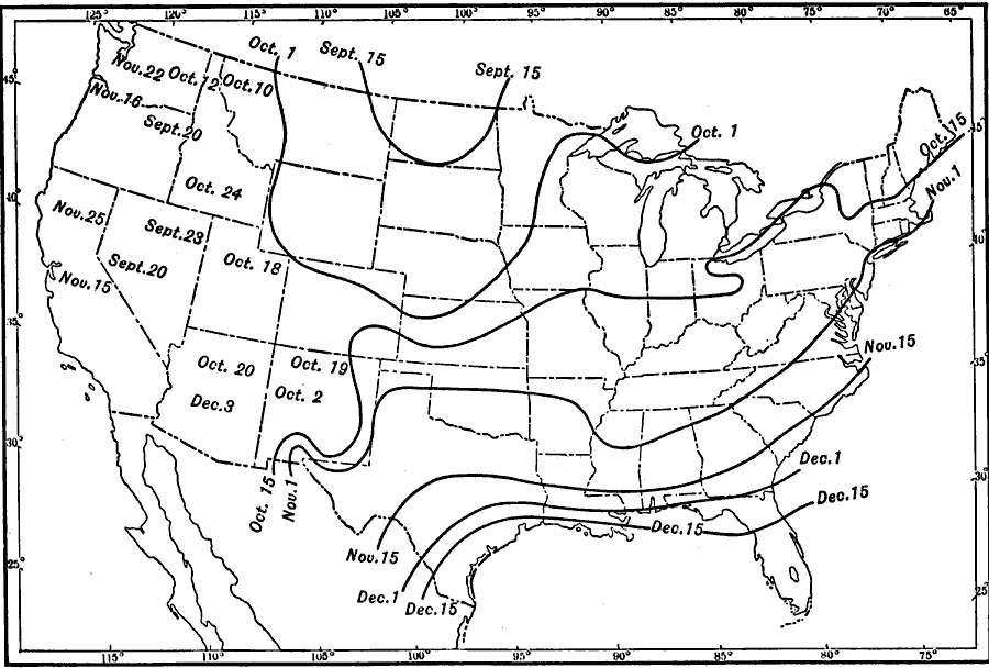
That map is a little small so, if we can assume 1911 was typical, here's a larger map showing basically the same thing, the day of the last killing frost:
As it turns out, there is a north-south population density trend in the Frontier Strip. Looking further north to Canada, any semblance of a 100 W-population boundary disappears. In fact the population density along the country's southern border increases beyond 100 W, after having dropped off in Ontario well to the east. Again, black line is 100 W.

You might make several arguments to explain this: 1) The 100W boundary is in fact country-specific, due to different development policies, and/or 2) that as latitude increases, the strength of the association of precipitation becomes relatively weaker and latitude becomes stronger. (Who cares about number of days below freezing when you go from 30 to 50? Precipitation makes a bigger difference. But when you go from 120 to 140, latitude makes a bigger difference.) 3) The western part of Ontario isn't yet at steady state and its population will growin the future when settlers arrive to realize its agricultural potential, and the precipitation-driven east-west density gradient will assert itself.
Rather than speculate, I did linear regressions on the Frontier Strip and Frontier plus Pacific and Arizona, using latitude, rainfall (not including snow), days below freezing, average annual temperature, lowest average monthly low, highest average monthly high, and population density, and their correlation to agricultural dollars per area. Rather than take up space with a bunch of ugly scatter plots I made a table of R^2 values. This is exploratory so there's no fancy Bonferroni corrections going on, but in any event none are strong correlations.
Since agricultural output is just a proxy for the original question we're concerned with (population density), I used that as the output and looked at the same factors. Wow. The R's are much stronger.
First: agricultural output and population density do not seem to be strongly related. Furthermore if rainfall is the reason 100 W is significant, it's interesting that rainfall is a much weaker predictor than temperature. These are both problems for the traditional 100 W theory.
Second, for the "inputs" with R's above 0.9, here's what they mean in terms of population density.
- For every day of the year where the temperature drops below freezing, the population density is lower by 0.197 people per square kilometer.
- For every degree lower the lowest monthly low is, the population density is lower by 0.863.
- For every degree the average annual temperature drops, the population density drops by 1.33.
- For every degree of latitude gained, the population density drops by 2.05.
It seems strange that there could be such a strong connection between climate and population but not agricultural output, especially in states where a huge fraction of the economy depends on agriculture. That connection could very well be concealed here by the limited set of agricultural products I'm considering. Really, what I should be using is climate and agriculture output data at the county level, and the agriculture data should be the value of all commercial livestock and crops. But I leave that to someone with access to real data and real software. It would also be interesting to crunch these numbers for every decade from 1850, and see how the R's and slopes for each of these change over time if at all. Maybe the weak predictiveness between climate factors and agricultural output is real, but it used to be much stronger.
PART 2. Other Possible Explanations
Explanation #1. The population drop-off is a result of timing, i.e. improvements in transportation and communication. Couldn't it just be that just as the Frontier Strip was getting settled, trains and telegraph lines were built? Finally, you could find out whether there were jobs in San Francisco, and you could get there. (Assuming that independent of mineral extraction revenues*, loss of population is equivalent to loss of economic growth, this is the root of productivity paradoxes that exist between areas with free movement of people and goods.
If this were the case, you would expect to see a shift westward from the Frontier Strip at least by the 1880s. The Transcontinental railroad was completed in 1869 and it was connected to Los Angeles in 1876. In fact this is not what we see. First, here are the population densities of all Frontier Strip states and Pacific coast states, and then the average density of both groups.


After the 1920s, the Pacific states never looked back. Among the Frontier states, Texas is by far the strongest performer, owing probably to a longer growing season, early discovery of mineral wealth, and ports to make transportation cheaper (though I suspect immigration from Mexico is also a contributor there; Texas Hispanics are 35.9% of the population, compared to 6.1% in neighboring Oklahoma and comparable or lower northward.) Furthermore, you can see there was a local optimum in every Frontier state except Texas sometime in the teens. I don't know of any events that would explain this drop, nor if people were heading further west. Bottom line, the fact that the drop happened so late argues against the railroads having been the contributor, and the roads weren't yet developed enough that cars could have been the explanation.
Initially I was also skeptical because of Arizona. Arizona is clearly not a state blessed with rainfall, and yet it had (and still has) a strong citrus growing industry (thanks to irrigation), and its population density passed the Frontier Strip's in the 1980s and is still growing. It's worth asking why irrigation doesn't also cause a sudden increase in the relatively wetter Frontier Strip's population; climate and sunshine preference are likely to play a part, and we could make a guess based on sources of internal immigration for Arizona. This would suggest that in some ways, transportation and information about local conditions do make a difference, but the precondition is that the area can't have been settled prior to modern irrigation technology (because capital commitments are made in the agricultural infrastructure), and it has to have sunlight. I think that the real explanation will have something to do with the random impact of the historical timing of technological progress, if not transportation, then commitment to pre-existing agricultural infrastructure, shifting of economic importance to other sectors, and population preferences that make a greater difference in more recent history due to increased mobility.
Explanation #2. The Okie Effect. Can farm abandonment and consolidation during the Depression and Dustbowl explain it? See graphs above. These economic/agricultural events may have contributed but the trend was already underway at least a decade earlier.
*I give the caveat about mineral wealth because Texas and to a lesser extent Oklahoma have big oil sectors that impact their populations. In addition, most of North Dakota's counties are losing population and the state is just barely growing but recent oil discoveries have made the state profitable. Research suggestion: to what degree can sub-national entities be subject to the resource curse? What institutions or cultural features are protective against resource-curse type damage to economies?
Since the 100 W theory of population density drop-off appears falsified, other explanations must be sought. The appearance of easier transportation during the settlement of the Frontier Strip, as well as the depression are explored and discarded. Further research with better agricultural output data and higher resolution climate data may support the hypothesis that investments in agricultural capital came too early in the Frontier Strip to benefit from irrigation technology, and that modern transportation and U.S. population preferences of climate as well as the coastal location of large population centers with service economies combine to keep the Frontier Strip the low-population boundary of the U.S. interior.
PART 1. I've written enough about the Bad Stripe recently so I thought I'd move to another grouping of U.S. states: the Frontier Strip. The Frontier Strip is the north-south line of states including the Dakotas, Nebraska, Kansas, Oklahoma and Texas, identified retrospectively in the 1890 census as having been the frontier in 1880. I've been interested in the idea ever since I visited Scottsbluff, Nebraska on a road trip two years ago. Like many places in the High Plains, Scottsbluff is proud of its pioneer heritage, although you have to ask how proud you want to be of being famous for being on the way to somewhere else. Inspection of a population density map of the U.S. shows that there is a dramatic drop-off as you move west across the Frontier Strip states, which never "recovers" until you hit the coastal cities of Washington, Oregon and California. The precipitation map is underneath it for comparison.

The geographers' conventional wisdom on this phenomenon involves the hundredth meridian west, which I've drawn in as a black stripe. It does seem to track just to the west of the density drop-off. The argument is that precipitation drops off to the west of this area, so agriculture becomes less productive. In earlier times economies were more strongly dependent on agriculture; consequently, large cities would not tend to develop in these dry regions and, even if they did, could not be supplied with food. Therefore further settlement coming from the East passed these areas and continued to the (contiguous) Pacific coast states. This argument also assumes that the potential agricultural productivity of an area has been realized by settlement and farming, i.e. it is at steady-state, and North Dakota's population isn't about to explode due to settlement by new farmers.
I've always found this argument dubious. First of all, most of these assumptions are not addressed explicitly in discussions of the 100 W boundary. But the most direct thing to do would be to look at agricultural output and see how it stacks up by state. Because states differ in population and size, we should look at output per person and per area. This information comes from the 2010 Census. There is not an obvious unit of "agricultural output" (if we include tobacco, none of the Frontier Strip or Pacific states will do very well) so I used combined receipts for the four principal products that the Census tracks by state (beef cattle, dairy products, corn and broiler chickens). Yes, wheat is an obvious omission but I couldn't find data for it by state, so it's possible these numbers are off by virtue of neglecting important crops.
So, if we have cause to doubt the traditional 100 W explanation, the Frontier Strip states should do the same or better than the Pacific states in agricultural output, meaning that it's not such a farm productivity death sentence to be near 100 W. Here's how the Frontier states and Pacific states stack up when ordered by agricultural value produced per-person.
| State | Ag $/person |
| Nebraska | 6,040 |
| South Dakota | 3,954 |
| Kansas | 2,846 |
| North Dakota | 2,091 |
| Oklahoma | 890 |
| Oregon | 590 |
| Texas | 451 |
| Washington | 286 |
| Arizona | 233 |
| California | 229 |
(I include Arizona because I'll use it later as an example.)
Before we get excited and declare 100 W theory dead, it should be noted that the above table probably isn't that interesting. We're looking at 2010 data, and even if California really is more productive than the Frontier states (as the traditional theory predicts), it might be masked in this table: states with large populations are likely to have higher proportions of people in other sectors, i.e. doing something other than agriculture. What really counts is the potential productivity of the land itself (owing to climate); that's the crux of the argument. So here's how they stack up when look at agricultural value produced per land area:
| State | Ag $/Area |
| Nebraska | 55,405 |
| Kansas | 38,319 |
| California | 21,154 |
| Oklahoma | 18,765 |
| Texas | 16,698 |
| South Dakota | 16,364 |
| Washington | 11,128 |
| Oregon | 9,080 |
| North Dakota | 7,598 |
| Arizona | 5,059 |
This doesn't look good for the 100 W theory. Yes, California is productive per land area, but still, if you're in Nebraska or Kansas, why go west? You're better off in the High Plains! There are possible explanations for this, besides the limited four-product index I'm using: a) The farming business has changed a lot over the past century and a half, and what used to be family-owned farms are now gigantic industrial facilities. So what makes Nebraska so productive now might not matter to people economically today (if it's all going to one or two corporations) or it might be different from conditions a century ago. b) You could also make the argument that dollars produced per area is a weak proxy indicator, because the land isn't being used for valuable crops, because the value of crops has changed over time, or (least likely) the areas haven't reached steady state and are still being developed by settlers agriculturally.
Additional point: agricultural productivity cannot depend entirely on precipitation, i.e. on proximity to 100 W. Length of growing season has something to do with it as well, which as you might guess has a strong north-south trend. This map shows number of days below freezing:

That map is a little small so, if we can assume 1911 was typical, here's a larger map showing basically the same thing, the day of the last killing frost:
As it turns out, there is a north-south population density trend in the Frontier Strip. Looking further north to Canada, any semblance of a 100 W-population boundary disappears. In fact the population density along the country's southern border increases beyond 100 W, after having dropped off in Ontario well to the east. Again, black line is 100 W.

You might make several arguments to explain this: 1) The 100W boundary is in fact country-specific, due to different development policies, and/or 2) that as latitude increases, the strength of the association of precipitation becomes relatively weaker and latitude becomes stronger. (Who cares about number of days below freezing when you go from 30 to 50? Precipitation makes a bigger difference. But when you go from 120 to 140, latitude makes a bigger difference.) 3) The western part of Ontario isn't yet at steady state and its population will growin the future when settlers arrive to realize its agricultural potential, and the precipitation-driven east-west density gradient will assert itself.
Rather than speculate, I did linear regressions on the Frontier Strip and Frontier plus Pacific and Arizona, using latitude, rainfall (not including snow), days below freezing, average annual temperature, lowest average monthly low, highest average monthly high, and population density, and their correlation to agricultural dollars per area. Rather than take up space with a bunch of ugly scatter plots I made a table of R^2 values. This is exploratory so there's no fancy Bonferroni corrections going on, but in any event none are strong correlations.
| All | Frontier | |
| Latitude | 0.0077 | 0.0039 |
| Rainfall | 0.0205 | 0.1513 |
| Frz Days | 0.0986 | 0.0014 |
| Ave Temp | 0.0216 | 0.0003 |
| Lowest Mnth Lo | 0.1123 | 0.0004 |
| Highest Mnth Hi | 0.0006 | 0 |
| Pop Dens | 0.0358 | 0.0125 |
Since agricultural output is just a proxy for the original question we're concerned with (population density), I used that as the output and looked at the same factors. Wow. The R's are much stronger.
| All | Frontier | |
| Latitude | 0.1355 | 0.9463 |
| Rainfall | 0.0484 | 0.4844 |
| Frz Days | 0.5628 | 0.9773 |
| Ave Temp | 0.2918 | 0.9475 |
| Lowest Mnth Lo | 0.6001 | 0.9577 |
| Highest Mnth Hi | 0.0117 | 0.8587 |
| Ag Output/Area | 0.0358 | 0.0125 |
First: agricultural output and population density do not seem to be strongly related. Furthermore if rainfall is the reason 100 W is significant, it's interesting that rainfall is a much weaker predictor than temperature. These are both problems for the traditional 100 W theory.
Second, for the "inputs" with R's above 0.9, here's what they mean in terms of population density.
- For every day of the year where the temperature drops below freezing, the population density is lower by 0.197 people per square kilometer.
- For every degree lower the lowest monthly low is, the population density is lower by 0.863.
- For every degree the average annual temperature drops, the population density drops by 1.33.
- For every degree of latitude gained, the population density drops by 2.05.
It seems strange that there could be such a strong connection between climate and population but not agricultural output, especially in states where a huge fraction of the economy depends on agriculture. That connection could very well be concealed here by the limited set of agricultural products I'm considering. Really, what I should be using is climate and agriculture output data at the county level, and the agriculture data should be the value of all commercial livestock and crops. But I leave that to someone with access to real data and real software. It would also be interesting to crunch these numbers for every decade from 1850, and see how the R's and slopes for each of these change over time if at all. Maybe the weak predictiveness between climate factors and agricultural output is real, but it used to be much stronger.
PART 2. Other Possible Explanations
Explanation #1. The population drop-off is a result of timing, i.e. improvements in transportation and communication. Couldn't it just be that just as the Frontier Strip was getting settled, trains and telegraph lines were built? Finally, you could find out whether there were jobs in San Francisco, and you could get there. (Assuming that independent of mineral extraction revenues*, loss of population is equivalent to loss of economic growth, this is the root of productivity paradoxes that exist between areas with free movement of people and goods.
If this were the case, you would expect to see a shift westward from the Frontier Strip at least by the 1880s. The Transcontinental railroad was completed in 1869 and it was connected to Los Angeles in 1876. In fact this is not what we see. First, here are the population densities of all Frontier Strip states and Pacific coast states, and then the average density of both groups.


After the 1920s, the Pacific states never looked back. Among the Frontier states, Texas is by far the strongest performer, owing probably to a longer growing season, early discovery of mineral wealth, and ports to make transportation cheaper (though I suspect immigration from Mexico is also a contributor there; Texas Hispanics are 35.9% of the population, compared to 6.1% in neighboring Oklahoma and comparable or lower northward.) Furthermore, you can see there was a local optimum in every Frontier state except Texas sometime in the teens. I don't know of any events that would explain this drop, nor if people were heading further west. Bottom line, the fact that the drop happened so late argues against the railroads having been the contributor, and the roads weren't yet developed enough that cars could have been the explanation.
Initially I was also skeptical because of Arizona. Arizona is clearly not a state blessed with rainfall, and yet it had (and still has) a strong citrus growing industry (thanks to irrigation), and its population density passed the Frontier Strip's in the 1980s and is still growing. It's worth asking why irrigation doesn't also cause a sudden increase in the relatively wetter Frontier Strip's population; climate and sunshine preference are likely to play a part, and we could make a guess based on sources of internal immigration for Arizona. This would suggest that in some ways, transportation and information about local conditions do make a difference, but the precondition is that the area can't have been settled prior to modern irrigation technology (because capital commitments are made in the agricultural infrastructure), and it has to have sunlight. I think that the real explanation will have something to do with the random impact of the historical timing of technological progress, if not transportation, then commitment to pre-existing agricultural infrastructure, shifting of economic importance to other sectors, and population preferences that make a greater difference in more recent history due to increased mobility.
Explanation #2. The Okie Effect. Can farm abandonment and consolidation during the Depression and Dustbowl explain it? See graphs above. These economic/agricultural events may have contributed but the trend was already underway at least a decade earlier.
*I give the caveat about mineral wealth because Texas and to a lesser extent Oklahoma have big oil sectors that impact their populations. In addition, most of North Dakota's counties are losing population and the state is just barely growing but recent oil discoveries have made the state profitable. Research suggestion: to what degree can sub-national entities be subject to the resource curse? What institutions or cultural features are protective against resource-curse type damage to economies?
Subscribe to:
Posts (Atom)